


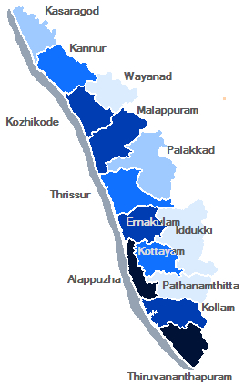
Kerala Travel Map
Kerala, a state in Southern India is known as a tropical paradise of waving palms and wide sandy beaches. It is a narrow strip of coastal territory that slopes down the Western Ghats in a cascade of lush green vegetation, and reaches to the Arabian sea. Interactive guide to Kerala with a full-screen map and photos. Information on Kerala sights, flights, hotels and more.
Kerala is a state in India. It is located on the south-western region of the country. It was created on 1 November 1956, with the passing of the States Reorganisation Act bringing together the areas where Malayalam was the dominant language.
The state has an area of 38,863 km2 and is bordered by Karnataka to the north, Tamil Nadu to the south and the east and the Lakshadweep Sea[note] towards the west. Thiruvananthapuram is the capital and largest city of Kerala. Kochi and Kozhikode are the other major cities. Kerala is also known for its many small towns that are scattered across the state.
District wise map
Thiruvananthapuram
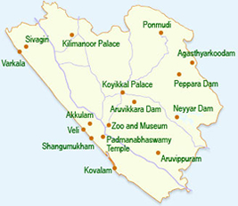
Thiruvananthapuram District is the southernmost district of the Indian state of Kerala. It came into existence in the year 1957. The headquarters is the city of Thiruvananthapuram (Trivandrum) which is also the capital city of Kerala.
The district has an area of 2192 km², and a population of 3,234,356 (as per the 2001 census), the second largest in Kerala. It is divided into four taluks, Thiruvananthapuram, Chirayinkeezhu, Neyyattinkara, Nedumangadu. The urban bodies in the district are the Thiruvananthapuram Corporation, Varkala, Neyyattinkara, Attingal and Nedumangad municipalities.
Download full size map
Kollam
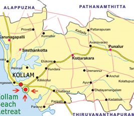
Kollam district, earlier known as Quilon district, is one among the 14 districts of Kerala state, India. The district is representative of all the natural attributes of Kerala and is endowed with a long coastal region, a major sea port on the Arabian Sea inland in Astamudi lake and was called Tarsish. Kollam is the capital of cashew trading and processing industry of kerala. Kollam is also known as The God's Own Capital
Plains, mountains, lakes, lagoons and Backwaters, forests, farm land and rivers constitutes the topography of the district. The area had mercantile relationship with Phoenicians and the Romans.
Download full size map
Pathanamthitta
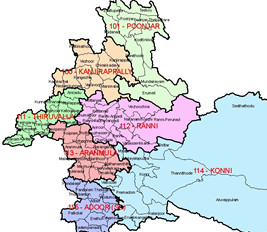
Pathanamthitta district is the youngest district located in the southern part of the state of Kerala, India. The district headquarters is in Pathanamthitta town. The district is surrounded by Kottayam, Idukki, Alappuzha and Kollam districts. It has a border with the state of Tamil Nadu in the east. Pathanamthitta, Tiruvalla, Adoor, Kozhencherry, Ranni and Konni are the major townships in the district
Pathanamthitta is known as the headquarters of pilgrimage tourism, for the large number of pilgrims it receives. The famous pilgrimage centre of Sabarimala, is situated here. Having three rivers and a forest cover which includes a tiger reserve, the district also attracts many wildlife and nature enthusiasts.
Download full size map
Alappuzha
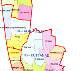
Alappuzha is one of the 14 districts in the state of Kerala in India. It was formed as Alleppey District on August 17, 1957. The name of the district was officially changed to Alappuzha in 1990. The district is a widely known tourist destination, and is well-known for its coir factories. Most of Kerala's coir industries are situated in and around Alappuzha. The district is also known for its communist traditions. It is home to the Punnapra Vayalar strikes against the British and also the revolt against feudal raj. Alappuzha is strongly connected by waterways to various other parts of Kerala, including the famous tourist destination, Kumarakom.
Download full size map
Kottayam
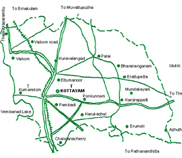
Kottayam is a city in the Indian state of Kerala. It is located in central Kerala and is also the administrative capital of Kottayam district. Kottayam has an estimated population of 60,725, according to the 2001 census. The town is an important trading center of spices and commercial crops, especially rubber. Major Kerala print media such as Malayala Manorama group and Deepika are headquartered in the city. Also a pioneering centre of modern education in Kerala, the city became India's first municipality to achieve 100% literacy in 1989 and the district became the first tobacco free district in India[citation needed]. The city of Kottayam is also called as "Akshara Nagari" which means the "City of Letters" considering its contribution to print media and literature.First Freedom Fighter Chempil Arayan Ananthapadmanabhan Valiya Arayan Kankumaran who fought at the Cochin Fort against the British Rule in 29 December 1808.Chempil Arayan was the commander in chief of Velu Thambi Dalawa.
Download full size map
Idukki
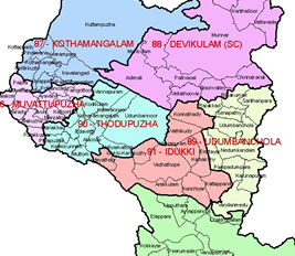
Idukki has an area of 5,105.22 km2 (1,971.1 sq mi) and is the second largest District of Kerala. Rugged mountains and forests cover about 97 percent of the total area of the District. The district borders the Kerala districts of Pathanamthitta to the south, Kottayam to the southwest, Ernakulam to the northwest and Thrissur to the north and Coimbature, Dindigul and Theni Districts in Tamilnadu to the east.
Anamudi, the highest peak in India south of Himalayas, is in the Kuttampuzha Panchayat of Adimali Block, in the Kannan Devan Hills Village of Devikulam taluk. 13 other peaks in the district exceed a height of 2,000 m (6,562 ft). The Periyar, Thodupuzhayar and Thalayar are the important rivers of the district.
Download full size map
Ernakulam

Ernakulam refers to the eastern part of the mainland of Kochi city in Kerala, India. The name 'Ernakulam' is derived from the name of a very famous temple of Lord Shiva called the Ernakulathappan Temple. It is also said that the word Ernakulam was drawn from Malayalam words 'Ere naal Kulam', which mean 'Pond for a long time'. Ernakulam is the commercial capital of the state of Kerala.The Kerala High Court is situated in Ernakulam.
Anamudi, the highest peak in India south of Himalayas, is in the Kuttampuzha Panchayat of Adimali Block, in the Kannan Devan Hills Village of Devikulam taluk. 13 other peaks in the district exceed a height of 2,000 m (6,562 ft). The Periyar, Thodupuzhayar and Thalayar are the important rivers of the district.
Download full size map
Thrissur
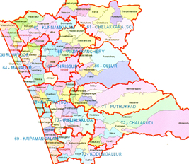
Thrissur ( Trichur / Trishur) is a revenue district of Kerala situated in the central part of India. Spanning an area of about 3,032 sq km, Thrissur district is home to over 10% of Kerala's population, a mix of traditionally rich and the neo-rich. Thrissur district was formed on July 1, 1949, with the headquarters at Thrissur City. Thrissur is known as the cultural capital of Kerala, and the land of Poorams. The district is famous for its ancient temples, churches, and mosques. Thrissur Pooram is the most colourful and spectacular temple festival in Kerala.
The name Thrissur is derived from 'Thiru-Shiva-Perur' , which translates to "The city with the name of the Lord Siva". Thrissur was also known as "Vrishabhadripuram" and "Then Kailasam" (Kailasam of the south) in ancient days.[citation needed] Another interpretation is 'Tri-shiva-peroor' or the big land with three Shiva temples, which refers to the three places where Lord Shiva resides - namely Vadakkunnathan temple, Asokeswaram Siva temple and Irattachira Siva temple.
Download full size map
Palakkad
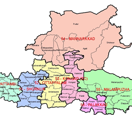
Palakkad District or Palghat is one of the 14 districts of Kerala state in South India. The city of Palakkad is the district headquarters. Palakkad is bordered on the northwest by the Malappuram District, on the southwest by the Thrissur District and on the east by Coimbatore district of Tamil Nadu. The district is 13.62% urbanised. The district is nicknamed "the granary of Kerala".
In earlier times Palakkad was also known as Palakkattussery. Some etymologists trace the word "Palakkad" from the word Palai nilam, which means "dry lands". The commonly held belief, however, is that the name is a fusion of two Malayalam words, Pala, a tree (Alstonia scholaris) that is found abundantly in Palakkad, and Kadu, which means forest.
Download full size map
Kozhikode
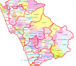
Kozhikode District is a district of Kerala state, situated on the southwest coast of India. The city of Kozhikode, also known as Calicut, is the district headquarters. The district is 38.25% urbanised.
Kozhikode district is bordered by the districts of Kannur to the north, Wayanad to the east, and Malappuram to the south.The Arabian Sea lies to the west. It is situated between latitudes 11° 08'N and 11° 50'N and longitudes 75° 30'E and 76° 8'E.
Download full size map
Malappuram
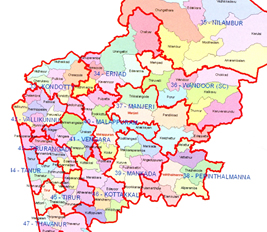
Malappuram District is a district in the south Indian state of Kerala. The district headquarters is at Malappuram. The district was formed on 16 June 1969.It is unique in that it is the only Muslim majority district in south India. The area was active during the Independence Movement and was the site of the Moplah Rebellion.
The district lies in northern Kerala and is bounded on the north by Wayanad and Kozhikkode districts, on the northeast by Tamil Nadu, on the southeast and south by Palakkad District, on the southwest by Thrissur District, on the west by the Arabian Sea, and on the northwest by Kozhikode District.
Download full size map
Wayanad
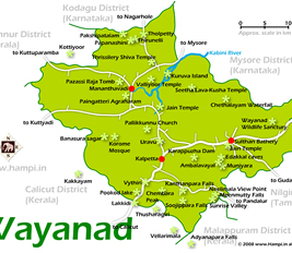
Wayanad District in the north-east of Kerala, India, was formed on November 1, 1980 as the 12th district by carving out areas from Kozhikode and Kannur districts. Kalpetta is the district headquarters as well as the only municipal town in the district. The region was known as Mayakshetra (Maya's land) in the earliest records. Mayakshetra evolved into Mayanad and finally to Wayanad. The Folk etymology of the word says it is a combination of Vayal (paddy field) and Naad (land), making it 'The Land of Paddy Fields'. There are many indigenous tribals in this area. It is set high on the majestic Western Ghats with altitudes ranging from 700 to 2100 m.
Download full size map
Kannur
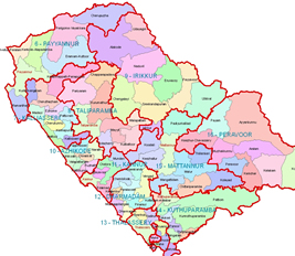
Kannur District is one of the 14 districts in the state of Kerala, India. The town of Kannur is the district headquarters, and gives the district its name. The old name Cannanore is the anglicised form of the Malayalam name Kannur. Kannur District is bounded by Kasaragod District to the north and Kozhikode District and Wayanad District to the south. To the east the district is bounded by the Western Ghats, which forms the border with Karnataka state, in its districts of Kodagu and Chamarajanagar. The Arabian Sea lies to the west.
Kannur is the most urbanised district in Kerala, with more than 50% of its residents living in urban areas. Kannur has an urban population of 1,212,898, which is the second largest in Kerala after Ernakulam district .
Download full size map
Kasaragod
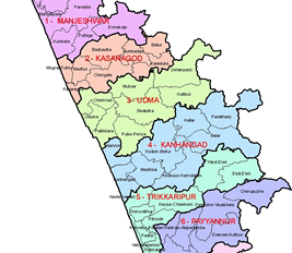
Kasaragod is one of the districts of the Indian state of Kerala. Kasaragod District was organised as a separate district on 24 May 1985.[1] It is the northernmost district of Kerala and is named after Kasaragod Town which is the administrative headquarters of the district.
Kannur is the most urbanised district in Kerala, with more than 50% of its residents living in urban areas. Kannur has an urban population of 1,212,898, which is the second largest in Kerala after Ernakulam district .
Download full size map
